فلسطینی د نورو بومي ملتونو سره ورته تجربې شریکې لري، هغه ملتونه چې د دوی د خپلواکۍ حق او د دوی روایت انکار شو، د دوی مادي کلتور ویجاړ شو، او د دوی تاریخونه د اروپايي سپین پوستي مېشتو او استعمارګرانو له خوا ړنګ، بیاځلې کیسه، نوی جوړ یا بدل شول. فرانسس جنینګز په خپل کتاب The Invasion of America (۱۹۷۵) کې د اروپايي سپین پوستي مېشتو د تسلط لرونکو روایتونو ته اشاره وکړه، او وویل چې د نسلونو لپاره تاریخ پوهانو د امریکا د بومي ملتونو په اړه د کلتوري برترۍ له مخې لیکنې کړې، هغه لیکنې چې د بومي ملتونو او د اروپايي مېشتو ترمنځ د اړیکو اصلي تاریخ یې ړنګ یا بدل کړ. په Decolonizing Methodologies کې:
The Palestinians share common experiences with other indigenous peoples who had their self-determination and narrative denied, their material culture destroyed and their histories erased, retold, reinvented or distorted by European white settlers and colonisers. In The Invasion of America (1975), Francis Jennings highlighted the hegemonic narratives of the European white settlers by pointing out that for generations historians wrote about the indigenous peoples of America from an attitude of cultural superiority that erased or distorted the actual history of the indigenous peoples and their relations with the European settlers. In Decolonizing Methodologies:
د اسلام او ښځو په اړه د ډیرو کتابونو په شان دا کتاب هم د دې مسئلې په اړه ځانګړی تاکید کوي.
Wait—that's not what was asked. Let me redo the translation properly.
د څیړنې او بومي خلکو په اړه، ماوري عالمه لینډا توهیوای سمیت استدلال کوي چې د اروپایي استعمار اغیز لاهم بومي خلکو ته زیان اړوي او تباه کوي؛ دا چې د بومي خلکو د تاریخ د نظرونو نفي کول د استعماري ایدیالوژۍ د ټینګولو کې یو مهم رول ولوباوه، یوه برخه یې دا وه چې بومي نظرونه غلط یا لرغونی بلل کیدل، خو لومړنی دلیل یې دا و چې «دوی د استعمار د ماموریت ننګونه او مخالفت کاوه» (Smith, L. 1999: 29). هغه وايي:
Research and Indigenous Peoples, Maori scholar Linda Tuhiwai Smith argues that the impact of European settler-colonisation is continuing to hurt and destroy indigenous peoples; that the negation of indigenous views of history played a crucial role in asserting colonial ideology, partly because indigenous views were regarded as incorrect or primitive, but primarily because ‘they challenged and resisted the mission of colonisation’ (Smith, L. 1999: 29). She states:
استعمار کے دوران مقامی لوگوں نے تاریخ کے ایک مغربی نظریے کے خلاف جدوجہد کی، اور اس کے باوجود اسی نظریے کے ساتھ ایک طرح کی شراکت بھی کی۔ ہم اکثر اپنی "تاریخ" کو دوسروں کے ذریعے بیان ہونے دیتے رہے، اور پھر جب ہم اسے دوبارہ بیان ہوتا سنتے تو خود اپنے ہی معاملات میں اجنبی بن جاتے۔ دنیا کے نقشوں نے ہماری اس حیثیت کو مزید پختہ کیا کہ ہم دنیا کے حاشیے پر ہیں، اگرچہ ہمیں اب بھی سلطنت کا حصہ سمجھا جاتا تھا۔ اس میں یہ بھی شامل تھا کہ ہمیں اپنی سرزمینوں کے لیے نئے نام سیکھنے پڑے۔ وفاداری کی دوسری علامات، جیسے کہ پرچم، بھی شاہی نصاب کا لازمی حصہ تھیں۔ دنیا کے ساتھ ہمارا رشتہ اور نظریہ پہلے ہی نئے سرے سے متعین کیا جا رہا تھا، کیونکہ ہمیں منظم طور پر اپنی ہی سرزمینوں کی تاریخ لکھنے سے باہر رکھا جا رہا تھا۔
Under colonialism indigenous peoples have struggled against a Western view of history and yet been complicit with the view. We have often allowed our ‘histories’ to be told and have then become outsiders as we heard them being retold ... Maps of the world reinforced our place on the periphery of the world, although we were still considered part of the Empire. This included having to learn new names for our lands. Other symbols of our loyalty, such as the flag, were also an integral part of the imperial curriculum. Our orientation to the world was already being redefined as we were being excluded systematically from the writing of the history of our own lands.
(اسمیت، ل. ۱۹۹۹: ۳۳)
(Smith, L. 1999: 33)
اگرچه د نکبې څخه مخکې د ځایونو د نومونو د تغییر ځینې ډولونه دوام درلود، خو د نکبې څخه وروسته د صهیونیستانو د ځایي نومونو ستراتیژیو د حافظې ړنګولو (memoricide) او د ځایي نومونو د ړنګولو لپاره ډیر سخت لاره ونیوله، او فلسطینیان یې د خپل تاریخ څخه جلا کړل. د ۱۹۴۸ کال په جریان کې او وروسته د سلګونو فلسطیني کلیو او ښارونو فزیکي ړنګول کیدو سره، اسرائیلي دولت اوس د اصلي فلسطیني ځایي نومونو حافظه د تاریخ او جغرافیې څخه له منځه وړلو ته ځانګړې پاملرنه وکړه.
Although continuing some of the pre-Nakba patterns, Zionist toponymic strategies in the post-Nakba period pursued more drastic memoricide and erasure and the detachment of the Palestinians from their history. With the physical destruction of hundreds of Palestinian villages and towns during and after 1948, the Israeli state now focused on the erasure of indigenous Palestinian toponymic memory from history and geography.
فلسطین کا ۱۹۴۸ میں جسمانی طور پر غائب ہو جانا، تاریخی فلسطین کی آبادیاتی اور سیاسی حقیقتوں کو مٹا دینا، اور فلسطینیوں کو تاریخ سے مٹا دینا، ایک بنیادی مسئلے کے گرد گھومتا ہے، جس کا سب سے اہم پہلو 'انکار' اور 'اثبات' کے درمیان کشمکش ہے (Said 1980؛ Abu-Lughod et al. 1991)۔ تاریخی فلسطین کو نقشوں اور کارٹوگرافی سے حذف کرنا نہ صرف نوزائیدہ ریاست کو مضبوط کرنے کے لیے تھا، بلکہ 'بائبلی بنی اسرائیل' کے زمانے اور جدید اسرائیلی ریاست کے درمیان 'نہ ٹوٹنے والے تعلق' کے افسانے کو پختہ کرنے کے لیے بھی تھا۔ فلسطین کے ماضی کی منظم خاموشی پر تبصرہ کرتے ہوئے مؤرخ ایلان پاپے نے اپنی کتاب The Ethnic Cleaning of Palestine میں 'ثقافتی یادداشت کے قتل' (cultural memoricide) کے نظریے کو برتا ہے، جس میں وہ ۱۹۴۸ کے بعد کے اسرائیل میں علمی، سیاسی اور فوجی سطح پر فلسطینی سرزمین کو عربی پن سے محروم کرنے کی منظم کوشش کو نمایاں کرتے ہیں: اس کے ناموں، مقامات، مذہبی مقامات، دیہاتوں، قصبوں اور شہری مناظر، اس کے قبرستانوں، کھیتوں، زیتون اور سنتروں کے باغات، اور وہ پھل جسے صبر (نیوپل کیکٹس) کہتے ہیں، یعنی وہ کانٹے دار ناشپاتیاں جو فلسطین کے عرب دیہاتوں کے اندر و آس پاس اور عرب باغات میں اگائی جاتی تھیں۔ پاپے یہاں ایک استعاراتی پالمپسٹ (palimpsest) کا تصور پیش کرتے ہیں، یعنی ایک قوم کی تاریخ کو مٹا کر اس پر دوسری قوم کی تاریخ لکھنا؛ کئی تہوں کو ایک ہی تہ میں تبدیل کر دینا (Pappe 2006: 225–234)۔
The physical disappearance of Palestine in 1948, the deletion of the demographic and political realities of historic Palestine and the erasure of Palestinians from history centred on certain key issues, the most important of which is the contest between a ‘denial’ and an ‘affirmation’ (Said 1980; Abu-Lughod et al. 1991). The deletion of historic Palestine from maps and cartography was not only designed to strengthen the newly created state but also to consolidate the myth of the ‘unbroken link’ between the days of the ‘biblical Israelites’ and the modern Israeli state. Commenting on the systematic silencing of the Palestinian past, historian Ilan Pappe, in The Ethnic Cleaning of Palestine, deploys the doctrine of cultural memoricide, where he highlights the systematic scholarly, political and military attempt in post-1948 Israel to de-Arabise the Palestinian terrain, its names, spaces, religious sites, its villages, towns and cityscapes, and its cemeteries, fields, and olive and orange groves, and the fruit called Saber (cactus), the prickly pears famously grown in and around Arab villages and cultivated in Arab gardens in Palestine. Pappe conceives of a metaphorical palimpsest at work here, the erasure of the history of one people in order to write that of another people over it; the reduction of many layers to a single layer (Pappe 2006: 225–234).
په نکبه وروسته دورې کې، د اسرایلي د نوم بدلولو ستراتیژۍ ځینې ځانګړتیاوې په 1948 څخه مخکې د فلسطیني عربي ځایي نومونو د غصب او تقلید د کړنو سره نږدې تعقیب شوې. د جغرافیايي ځایونو تاریخي عربي نومونه د توراتي یا تلمودي نومونو سره، چې د هغو د یادونې پر بنسټ راڅرګند شول، او نوي جوړ شوي عبري نومونو سره بدل شول، چې ځینې یې د توراتي نومونو سره په ناڅرګنده توګه ورته والی درلود.
In the post-Nakba period, some of the features of the Israeli renaming strategy closely followed pre-1948 practices of appropriation of Palestinian Arabic toponyms and mimicry. The historic Arabic names of geographical sites were replaced by evoked biblical or Talmudic names and newly coined Hebrew names, some of which vaguely resembled biblical names.
دا مخکې ښودل شوي دي چې د عربي ځایونو بدلول او د فلسطین د جغرافیايي ځایونو نوم بدلول تقریباً هغه لارښوونو سره سم وو چې په نولسمه پېړۍ کې ایډوارډ رابنسن (1841؛ رابنسن او نور) وړاندې کړي وو.
It has already been shown that the replacement of Arabic places and the renaming of Palestine’s geographical sites followed roughly the guidelines suggested in the 19th century by Edward Robinson (1841; Robinson et al.
د ۱۸۶۰ کال. د توراتي ځمکپوهنې (بایبلیکل آرکیالوژۍ) او د مقدسو کتابونو د جغرافیې سره مینه د فلسطیني عربي ځایونو نومونه، فلسطیني جغرافیايي ځایونه او د فلسطین ځمکنی منظره د صهیونیستي تقلید او پټولو موضوع بدله کړه (یاکوبي ۲۰۰۹: ۱۱۵). د نولسمې پېړۍ له پیله تر شلمې پېړۍ د لومړۍ نیمایي پورې، لویدیځ استعماري تصور، توراتي منظرهییزې نقاشۍ، تخیلي او غیرعادي سفرنامې، د لویدیځ د شرقپوهانو توراتي علمي څیړنې، د مقدس ځمکې ځمکپوهنه، نقشهجوړونه او د مقدسو کتابونو جغرافیه د منځنی ختیځ کې د لویدیځ استعماري بریا لپاره حیاتي وې، «د توراتي ځمکو» بیا جوړونه وه، د تاریخ څخه بېبرخې لومړنۍ عبري توکم بیا اختراع کول وو، او په ورته وخت کې د فلسطیني تاریخ چوپ کول او د فلسطیني ځایونو نومونو څخه د عربي اصالت لرې کول وو (مسلحه ۲۰۰۷؛ ویټلم ۱۹۹۶؛ لانګ ۱۹۹۷، ۲۰۰۳).
1860). The obsession with biblical archaeology and scriptural geography transformed Palestinian Arabic place names, Palestinian geographical sites and the Palestinian landscape into subjects of Zionist mimicry and camouflaging (Yacobi 2009: 115). From the 19th century and throughout the first half of the 20th century Western colonialist imagination, biblical landscape painting, fantasy and exotic travel accounts, Orientalist biblical scholarship, Holy Land archaeology, cartography and scriptural geography have been critical to the success of the Western colonial enterprise in the Middle East, recreating the ‘Biblelands’, reinventing ahistorical-primordial Hebrew ethnicity, while at the same time silencing Palestinian history and de-Arabising Palestinian toponomy (Masalha 2007; Whitelam 1996; Long 1997, 2003).
د اسرائیل بیبلیکل صنعت، د عبرانی نومونو د بدلولو پروژو سره، د دې ډیر بډایه او ډیر مالي ملاتړ شوي استعماري دود پر بنسټ ولاړ و.
Israel’s biblical industry, with its Hebrew renaming projects, was embedded in this richly endowed and massively financed colonial tradition.
اسرائیلی تاریخدان ایلان پاپه فرمایی:
Israeli historian Ilan Pappe remarks:
[په ۱۹۴۸ او ۱۹۴۹ کلونو کې د ځمکې] حالت په ناڅرګنده توګه بدل شو. کلیوالي سیمه، د فلسطین کلیوالي زړه، د خپلو رنګین او ښکلو کلیو سره، ویجاړه شوه. نیمایي کلي وران شوي وو، د اسرائیلي بولډوزرونو له لارې ځمکې ته برابر شوي، چې د ۱۹۴۸ د اګست له میاشتې راهیسې کار ته بوخت وو، کله چې حکومت پریکړه کړې وه چې دا کلي یا د کرنې ځمکې ته واړوي یا د دوی پر پاتې شونو نوي یهودي ټولنې جوړې کړي.
[In 1948–1949 the land] changed beyond recognition. The countryside, the rural heart of Palestine, with its colourful and picturesque villages, was ruined. Half the villages had been destroyed, flattened by Israeli bulldozers which had been at work since August 1948 when the government had decided to either turn them into cultivated land or to build new Jewish settlements on their remains.
یوں ایک نامگذاری کمیٹی نے نئی بستیوں کو اصل عربی ناموں کے عبرانی شدہ [sic] روپ دیے: لوبیا کو "لیوی" بنا دیا گیا، اور صفوریہ [Saffuriyah] کو زیپوری [Tzipori] … ڈیوڈ بن گوریون نے وضاحت کی کہ یہ اقدام ان دیہاتوں پر مستقبل میں کیے جانے والے دعوے کو روکنے کی کوشش کے طور پر کیا گیا تھا۔
A naming committee granted the new settlements Hebraized [sic] versions of the original Arab names: Lubya became Lavi, and Safuria [Saffuriyah] Zipori [Tzipori] … David Ben-Gurion explained that this was done as part of an attempt to prevent future claim to the villages.
دې نقشې ته د اسرائیلي ارکیالوجستانو هم ملاتړ وکړ، چې دوی د ځایونو نومونو په تصویب سره نقشه د «لرغونې اسرائیل» سره ورته کولو ته راوستله۔ ([Pappe 2004: 138–139])
It was also supported by the Israeli archaeologists, who had authorized the names as returning the map to something resembling ‘ancient Israel’. (Pappe 2004: 138–139)
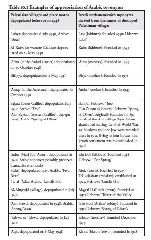
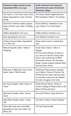
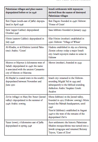
په فلسطیني کلیو کې چې خلک یې ویستل شوي او ویجاړ شوي وو، د یهودو مېشتګاوې جوړې شوې. ډېری حالاتو کې دغو مېشتګاوو د اصلي فلسطیني کلیو نومونه غوره کړل او هغه یې په عبراني ښکارندو نومونو بدل کړل. د فلسطیني میراث دغه پراخه غصب د اروپايي یهودي استعمارګرو دې ادعا ته ملاتړ وکړ چې گواکه دوی د دوه زره کلنې جلاوطنۍ وروسته خپلې وطن ته بېرته راګرځېدلي یو اصلي قوم دی. د مثال په توګه، هغه یهودي مېشتګاه چې د لوی او شتمن کلي بیت دجان ځای ونېوه (فلسطیني فلستیني «د داګون کور»، چې په ۱۹۴۸ کال کې ۵۰۰۰ اوسیدونکي لرل)، ۱۹۴۸ کال کې جوړه شوه او بیت داګون ونومول شوه؛ کیبوتز ساساء د ساساء کلي پر ځای جوړ شو؛ د عمقا کلي پر ځای تعاوني موشاو عمیقا جوړ شو (واکیم ۲۰۰۱الف، ۲۰۰۱ب؛ بوقاعي ۲۰۰۵: ۷۳). په جلیل کې الکبري کلی کبري ونومول شو؛ د البسه کلي نوم بتزات شو؛ د المجیدل کلي (د ناصره په شا) نوم میګدل هاعیمیک (د دره برج) شو. یوازې د طبریه په سیمه کې د ۱۹۴۸ کال څخه مخکې ستۍ عربي کلي وې؛ له دې جملې څخه پنځه ویشت یې، په دې کې دلهمیه، ابوشوشه، کفر سبت، لوبیا، الشجره، المجدل او حطین هم شامل دي، د اسرائیل له خوا ویجاړ شول. د حطین نوم - هغه ځای چې صلاح الدین (عربي: صلاح الدین) په ۱۱۸۷ کال د حطین په جنګ کې لاتینی صلیبیان ماتې ورکړه، چې د صلیبیانو د محاصرې او ماتې لامل شو، هغوی چې یروشلم یې کنټرول کاوه - د عبراني ښکارندو کفر حټیم (د غنمو کلی) سره بدل شو. په ۲۰۰۸ کال کې د اسرائیل د ځمکو ادارې، چې د فلسطیني کډوالو ملکیت کنټرولوي، د کلي ځمکه یوه نوې پراختیايي پروژې ته ورکړه: د ۱۵۰ میلیونه ډالرو خصوصي ګولف ریزورټ، چې د اتلس سوریو چمپیین ګولف ډګر لرل او د امریکايي رابرټ ټرینټ جونز جونیر لخوا ډیزاین شوی و. نږدې، د طبریه سړک د مناحیم بیګن بلوار ونومول شو؛ د حطین د ویجاړ شوي جومات دروازې ته درنې اوسپنیزې میلې ږدې شوې، او د منارې د زینو لاره بنده شوه (لیوی ۲۰۰۴).
Jewish settlements were established on the land of the depopulated and destroyed Palestinian villages. In many cases these settlements took the names of the original Palestinian villages and distorted them into Hebrewsounding names. This massive appropriation of Palestinian heritage provided support for the European Jewish colonisers’ claim to represent an indigenous people returning to its homeland after 2000 years of exile. For instance, the Jewish settlement that replaced the large and wealthy village of Beit Dajan (the Philistine ‘House of Dagon’; with 5000 inhabitants in 1948) was named Beit Dagon; founded in 1948; Kibbutz Sa’sa’ was built on Sa’sa’ village; the cooperative moshav of ‘Amka on the land of ‘Amqa village (Wakim 2001a, 2001b; Boqa’i 2005: 73). Al-Kabri in the Galilee was renamed Kabri; al-Bassa village was renamed Batzat; al-Mujaydil village (near Nazareth) was renamed Migdal Haemek (Tower of the Valley). In the region of Tiberias alone there were twenty-seven Arab villages in the pre-1948 period; twenty-five of them, including Dalhamiya, Abu Shusha, Kafr Sabt, Lubya, al-Shajara, al-Majdal and Hittin, were destroyed by Israel. The name Hittin – where Saladin (in Arabic: Salah al-Din) famously defeated the Latin Crusaders in the Battle of Hattin in 1187, leading to the siege and defeat of the Crusaders who controlled Jerusalem – was changed to the Hebrew-sounding Kfar Hittim (Village of Wheat). In 2008 the Israel Land Authority, which controls Palestinian refugee property, gave some of the village’s land to a new development project: a $150 million private golf resort, which was to have an eighteen-hole championship golf course, designed by the American Robert Trent Jones Jr. Nearby, the road to Tiberias was named the Menachem Begin Boulevard; heavy iron bars were placed over the entrance to Hittin’s ruined mosque, and the staircase leading to its minaret was blocked (Levy 2004).
په مرج بن عامر (د یزرعیل دره) کې د کیبوتز عین دور (د دور چینه)
In Marj Ibn ‘Amer (the Jezreel Valley) Kibbutz Ein Dor (Dor Spring)
دا کلی په ۱۹۴۸ کال کې د سوسیالیستي صهیونیستي ځوانانو تحریک "هشومیر هاتزایر" (وروسته "مپام") غړو او د هنګري او متحده ایالاتو مهاجرو ګډ تاسیس کړ. دا د "اندور" کلي په ځمکه تاسیس شو، هغه کلی چې خلک یې ویستل شوي وو او ویجاړ شوی و، او د ناصرې څخه ۱۰ کیلومټره سویلي ختیځ ته واقع دی.
was founded in 1948 by members of the socialist Zionist Hashomer Hatza’ir (later Mapam) youth movement and settlers from Hungary and the United States. It was founded on the land of the depopulated and destroyed village of Indur, located 10 kilometres south-east of Nazareth.
لوه دا چې آیا عربي نوم د لرې زمانې کنعاني ښار "ایندور" ساتلی و که نه، روښانه نه ده. له ۱۹۴۸ وروسته د ډیری اوسیدونکو د ځینو کسان په اسراییل کې داخلي کډوال شول (د اسرایېلي قانون له مخې "حاضر غایبان")، اسرایېلي تابعیت یې ترلاسه کړ، خو ایندور ته بېرته راتګ ورته نه و اجازه شوې. د نوي ځایونو او ټولنو ته د توراتي نومونو ورکولو د عام صهیونیستي دود سره سم، د هشومر هتزایر ملحد میشته کسانو عربي نوم ځان ته وګرځاوه، داسې ادعا کوي چې عین دور نوم د سموئیل کتاب (۲۸:۳‒۱۹) کې یادې شوې "توراتي کلي" په نوم کېښودل شوی. په هرصورت، دا هیڅکله په یقین سره نه شي ویلای چې د کیبوتز ځای د هغه "توراتي کلي" له ځای سره نږدې دی. د کیبوتز په کې یو لرغونتون موزیم د سیمې د تاریخ څخه مخکې دورې موندنې ساتي.
Whether or not the Arabic name preserved the ancient Indur, a Canaanite city, is not clear. After 1948 many of the inhabitants became internal refugees in Israel (‘present absentees’, according to Israeli law) and acquired Israeli citizenship, but were not allowed to return to Indur. In accordance with the common Zionist practice of bestowing biblical names on modern sites and communities, the atheist settlers of Hashomer Hatza’ir appropriated the Arabic name, claiming that Ein Dor was named after a village mentioned in Samuel (28:3‒19). However, it is by no means certain that the kibbutz’s location is anywhere near to where the ‘biblical village’ stood. An archaeological museum at the kibbutz contains prehistoric findings from the area.
مرکزی ملک کے اندر ایک زمانے میں آباد اور خوشحال قدیم فلسطینی شہر بیت جبرین، جو الخلیل شہر سے بیس کلومیٹر شمال مغرب میں واقع تھا، ۱۹۴۸ میں اسرائیلی فوج نے تباہ کر دیا۔ اس شہر کا آرامی نام بیت گبرا تھا، جس کا ترجمہ "[طاقتور] مردوں کا گھر" ہے؛ عربی میں بیر جبرین کا مطلب بھی "طاقتوروں کا گھر" ہے، جو ممکن ہے اس کے اصل آرامی نام کی عکاسی کرتا ہو۔ عبرانی لگنے والا کibbutz بیت گووրین (مردوں کا گھر)، جس کا نام ایک تلمودی روایت پر رکھا گیا، ۱۹۴۹ میں بیت جبرین کی زمینوں پر قائم کیا گیا، اور اسے ان سپاہیوں نے بسایا جنہوں نے پلماح اور اسرائیلی فوج چھوڑ دی تھی۔ آج اس مقام پر بازنطینی اور صلیبی جنگجوؤں کے آثار باقی ہیں، جو بیت گووրین کے عبرانی نام کے تحت ایک آثارِ قدیمہ کے مقام کے طور پر محفوظ ہیں؛ اس جگہ کے عرب اسلامی ورثے کو مکمل طور پر نظرانداز کر دیا گیا ہے۔
In the centre of the country the once thriving ancient Palestinian town of Beit Jibrin, 20 kilometres north-west of the city of al-Khalil, was destroyed by the Israeli army in 1948. The city’s Aramaic name was Beth Gabra, which translates as the ‘house of [strong] men’; in Arabic Beir Jibrin also means ‘house of the powerful’, possibly reflecting its original Aramaic name; the Hebrew-sounding kibbutz of Beit Guvrin (House of Men), named after a Talmudic tradition, was established on Beit Jibrin’s lands in 1949, by soldiers who left the Palmah and Israeli army. Today Byzantine and Crusader remains survive and are protected as an archaeological site under the Hebrew name of Beit Guvrin; the Arab Islamic heritage of the site is completely ignored.