10.14 シオニスト入植者と中世ラテン十字軍の伝説的な地名論
10.14 The Legendary Toponymy Of Zionist Settlers And The Latin Medieval Crusaders
イスラエルの地名改称委員会は、19世紀のキリスト教の聖書地理学者や聖書考古学者、たとえばヴィクトール・ゲランやエドワード・ロビンソンの方法に従いました。彼らは、モーリス・アルブヴァクスの『聖地福音書の伝説的地形学:集合的記憶の研究』(1941年)に登場するラテン系の中世十字軍巡礼者たちと同様に、聖書、タルムード、ミシュナの神話的な物語から特定の地名を「発見」し、作り出し、再生産しました。
Israeli renaming committees followed the methods of Christian scriptural geographers and biblical archaeologists of the 19th century such as Victor Guérin and Edward Robinson who, like the Latin medieval Crusader pilgrims in Maurice Halbwachs’ La Topographie légendaire des évangiles en terre sainte: étude de mémoire collective (1941), ‘discovered’, produced and reproduced particular place names from the myth narratives of the Bible, Talmud and Mishna.
トポニミサイド、模倣、そして脱アラブ化:パレスチナの遺産の横取りとパレスチナの過去の抹消
Toponymicide, Mimicry And De-arabisation: Appropriating Palestinian Heritage, Erasing The Palestinian Past
パレスチナ人は、自己決定権と語りを否定され、物質文化を破壊され、欧州の白人入植者や植民者によって歴史を消去、語り直し、再創造、あるいは歪曲されてきた他の先住民族と、共通の経験を分かち合っている。フランシス・ジェニングズは『アメリカの侵略』(1975年)において、欧州の白人入植者による覇権的な語りを指摘した。彼によれば、何世代にもわたって歴史家たちは文化的優越の姿勢からアメリカ先住民について書き、その結果、先住民の実際の歴史と欧州入植者との関係は消し去られ、あるいは歪められてきたのである。『脱植民地化の方法論』では、
The Palestinians share common experiences with other indigenous peoples who had their self-determination and narrative denied, their material culture destroyed and their histories erased, retold, reinvented or distorted by European white settlers and colonisers. In The Invasion of America (1975), Francis Jennings highlighted the hegemonic narratives of the European white settlers by pointing out that for generations historians wrote about the indigenous peoples of America from an attitude of cultural superiority that erased or distorted the actual history of the indigenous peoples and their relations with the European settlers. In Decolonizing Methodologies:
「先住民の研究とリサーチ」 マオリの学者リンダ・トゥヒワイ・スミスは、ヨーロッパの入植者による植民地化の影響が今なお先住民を傷つけ、破壊し続けていると主張している。また、先住民の歴史観が否定されたことは植民地イデオロギーを主張する上で決定的な役割を果たしたと論じている。その理由の一つは、先住民の見方が誤っているor原始的だとみなされたことにあるが、主たる理由は「それらが植民地化という使命に異を唱え、抵抗したから」である(Smith, L. 1999: 29)。スミスは次のように述べている。
Research and Indigenous Peoples, Maori scholar Linda Tuhiwai Smith argues that the impact of European settler-colonisation is continuing to hurt and destroy indigenous peoples; that the negation of indigenous views of history played a crucial role in asserting colonial ideology, partly because indigenous views were regarded as incorrect or primitive, but primarily because ‘they challenged and resisted the mission of colonisation’ (Smith, L. 1999: 29). She states:
植民地支配のもとで、先住民は西洋的な歴史観に抗ってきた一方で、その歴史観に加担してしまってもきた。私たちはしばしば自分たちの「歴史」を語る役割を他者に委ね、その物語が語り直されるのを聞くうちに、自らが部外者になっていった……。世界地図は、私たちが世界の周縁に位置するものであることを強化したが、それでも私たちは帝国の一部とみなされていた。それには、自分たちの土地の新しい名称を覚えることも含まれていた。旗のような忠誠の他の象徴も、帝国のカリキュラムに不可欠な要素であった。自分たちの土地の歴史の記述から体系的に排除されていく中で、世界に対する私たちの方向感覚は、すでに組み替えられつつあったのである。
Under colonialism indigenous peoples have struggled against a Western view of history and yet been complicit with the view. We have often allowed our ‘histories’ to be told and have then become outsiders as we heard them being retold ... Maps of the world reinforced our place on the periphery of the world, although we were still considered part of the Empire. This included having to learn new names for our lands. Other symbols of our loyalty, such as the flag, were also an integral part of the imperial curriculum. Our orientation to the world was already being redefined as we were being excluded systematically from the writing of the history of our own lands.
(Smith, L. 1999: 33)
(Smith, L. 1999: 33)
ナクバ以前の慣行の一部を引き継ぎつつも、ナクバ後の時期におけるシオニストの地名政策は、より徹底した記憶の抹消と消去、そしてパレスチナ人を自らの歴史から切り離すことを追求した。1948年の間およびその後に数百のパレスチナの村や町が物理的に破壊されると、イスラエル国家は今や、先住のパレスチナ人の地名に関する記憶を歴史と地理から消し去ることに焦点を当てた。
Although continuing some of the pre-Nakba patterns, Zionist toponymic strategies in the post-Nakba period pursued more drastic memoricide and erasure and the detachment of the Palestinians from their history. With the physical destruction of hundreds of Palestinian villages and towns during and after 1948, the Israeli state now focused on the erasure of indigenous Palestinian toponymic memory from history and geography.
1948年のパレスチナの物理的な消失、歴史的パレスチナの人口的・政治的現実の抹消、そして歴史からのパレスチナ人の抹殺は、いくつかの中心的な問題を軸に展開してきた。そのうち最も重要なのは、「否認」と「肯定」との間の争いである(Said 1980; Abu-Lughod et al. 1991)。歴史的パレスチナを地図や地図製作から削除したことは、新たに建国された国家を強化するためだけでなく、「聖書のイスラエル人」の時代と現代イスラエル国家とのあいだの「途切れることのない繋がり」という神話を固めるためにも行われた。パレスチナの過去が組織的に沈黙させられた状況について、歴史家イラン・パペは『パレスチナの民族浄化』において「文化的記憶抹殺」という概念を用い、1948年以後のイスラエルにおいて、学術、政治、軍事の各方面が組織的に、パレスチナの土地からアラブ的要素を消し去ろうとしてきたことを明らかにしている。その対象は、地名、空間、宗教施設、村落、町、都市景観、墓地、畑、オリーブやオレンジの果樹園、さらにはサベル(サボテン)と呼ばれる果実、すなわちパレスチナのアラブ人の村々の周辺や庭園で広く栽培されてきたウチワサボテンの実にまで及ぶ。パペはここに、比喩的な「重ね書き羊皮紙(パリンプセスト)」が働いていると捉える。ある民族の歴史を消し去り、その上に別の民族の歴史を書き込むこと、すなわち多くの層を単一の層へと還元することである(Pappe 2006: 225–234)。
The physical disappearance of Palestine in 1948, the deletion of the demographic and political realities of historic Palestine and the erasure of Palestinians from history centred on certain key issues, the most important of which is the contest between a ‘denial’ and an ‘affirmation’ (Said 1980; Abu-Lughod et al. 1991). The deletion of historic Palestine from maps and cartography was not only designed to strengthen the newly created state but also to consolidate the myth of the ‘unbroken link’ between the days of the ‘biblical Israelites’ and the modern Israeli state. Commenting on the systematic silencing of the Palestinian past, historian Ilan Pappe, in The Ethnic Cleaning of Palestine, deploys the doctrine of cultural memoricide, where he highlights the systematic scholarly, political and military attempt in post-1948 Israel to de-Arabise the Palestinian terrain, its names, spaces, religious sites, its villages, towns and cityscapes, and its cemeteries, fields, and olive and orange groves, and the fruit called Saber (cactus), the prickly pears famously grown in and around Arab villages and cultivated in Arab gardens in Palestine. Pappe conceives of a metaphorical palimpsest at work here, the erasure of the history of one people in order to write that of another people over it; the reduction of many layers to a single layer (Pappe 2006: 225–234).
戦後のナクバ(大災厄)以降の時期、イスラエルによる改名戦略の特徴の中には、1948年以前のパレスチナ・アラブ地名の横取りや模倣の慣行を忠実になぞったものがあった。歴史的なアラビア語の地名は、聖書やタルムードに由来するとされる名称や、新たに作られたヘブライ語の名称に置き換えられ、そのうちのいくつかは聖書の名前にかすかに似せられていた。
In the post-Nakba period, some of the features of the Israeli renaming strategy closely followed pre-1948 practices of appropriation of Palestinian Arabic toponyms and mimicry. The historic Arabic names of geographical sites were replaced by evoked biblical or Talmudic names and newly coined Hebrew names, some of which vaguely resembled biblical names.
以前から示されてきたように、アラビア語の地名の置き換えやパレスチナの地理的な場所の改名は、おおむね19世紀にエドワード・ロビンソン(1841年、Robinson et al.)が提案した指針に沿って行われた。
It has already been shown that the replacement of Arabic places and the renaming of Palestine’s geographical sites followed roughly the guidelines suggested in the 19th century by Edward Robinson (1841; Robinson et al.
19世紀から20世紀前半にかけて、聖書考古学と聖書地理学への執着は、パレスチナのアラビア語地名、パレスチナの地理的な場所、そしてパレスチナの景観を、シオニストによる模倣と偽装の対象へと変えていった(Yacobi 2009: 115)。19世紀から20世紀前半を通じて、西洋の植民地主義的な想像力、聖書的風景画、空想的で異国情緒あふれる旅行記、オリエンタリズム的な聖書学、聖地考古学、地図作成、聖書地理学は、中東における西洋の植民地事業を成功させるうえで決定的な役割を果たした。それらは「聖書の地」を作り上げ、非歴史的で原初的なヘブライ民族の像を再発明する一方で、パレスチナの歴史を沈黙させ、パレスチナの地名からアラビア的要素を消し去っていった(Masalha 2007; Whitelam 1996; Long 1997, 2003)。
1860). The obsession with biblical archaeology and scriptural geography transformed Palestinian Arabic place names, Palestinian geographical sites and the Palestinian landscape into subjects of Zionist mimicry and camouflaging (Yacobi 2009: 115). From the 19th century and throughout the first half of the 20th century Western colonialist imagination, biblical landscape painting, fantasy and exotic travel accounts, Orientalist biblical scholarship, Holy Land archaeology, cartography and scriptural geography have been critical to the success of the Western colonial enterprise in the Middle East, recreating the ‘Biblelands’, reinventing ahistorical-primordial Hebrew ethnicity, while at the same time silencing Palestinian history and de-Arabising Palestinian toponomy (Masalha 2007; Whitelam 1996; Long 1997, 2003).
イスラエルの聖書産業は、ヘブライ語への改名事業とともに、この潤沢な資金に支えられた大規模な植民地的伝統のなかに組み込まれていた。
Israel’s biblical industry, with its Hebrew renaming projects, was embedded in this richly endowed and massively financed colonial tradition.
イスラエルの歴史家イラン・パッペは次のように述べている。
Israeli historian Ilan Pappe remarks:
[1948〜1949年の間に、その土地は見分けがつかないほど変わってしまった。] 田園地帯、すなわちパレスチナの農村部の中心は、色鮮やかで絵のように美しい村々とともに荒廃した。村の約半数が破壊され、1948年8月以降、政府がそれらの跡地を耕作地に変えるか、その残骸の上に新たなユダヤ人入植地を建設することを決定して以来稼働していたイスラエルのブルドーザーによって、平らにならされたのである。
[In 1948–1949 the land] changed beyond recognition. The countryside, the rural heart of Palestine, with its colourful and picturesque villages, was ruined. Half the villages had been destroyed, flattened by Israeli bulldozers which had been at work since August 1948 when the government had decided to either turn them into cultivated land or to build new Jewish settlements on their remains.
委員会は新しい入植地に、元のアラビア語名のヘブライ語化された名称を与えた。ルビヤはラビとなり、サフリーヤ[Saffuriyah]はツィポリ[Tzipori]となった……。ダヴィド・ベン=グリオンは、これは将来の村の領有権主張を防ぐための試みの一環として行われたと説明した。
A naming committee granted the new settlements Hebraized [sic] versions of the original Arab names: Lubya became Lavi, and Safuria [Saffuriyah] Zipori [Tzipori] … David Ben-Gurion explained that this was done as part of an attempt to prevent future claim to the villages.
それはまた、古代「イスラエル」に近いものへと地図を立て直すことを目的として、その地名を認可していたイスラエルの考古学者たちによっても支持された。(Pappe 2004: 138–139)
It was also supported by the Israeli archaeologists, who had authorized the names as returning the map to something resembling ‘ancient Israel’. (Pappe 2004: 138–139)
ユダヤ人入植地は、人口が減らされ破壊されたパレスチナの村々の土地に建設された。多くの場合、これらの入植地は元のパレスチナ村の名前を取り、それをヘブライ語風の名前に歪めた。パレスチナの遺産のこの大規模な横領は、ヨーロッパのユダヤ人入植者が2000年の亡命の後に故郷へ帰還する先住民を代表するという主張を支えた。例えば、豊かな大村ベイト・ダジャン(ペリシテ人の「ダゴンの家」、1948年の人口5000人)に取って代わったユダヤ人入植地は、ベイト・ダゴンと名付けられ、1948年に設立された。キブツ・ササは、ササ村の上に建設された。協同組合モシャヴ・アムカは、アムカ村の土地に建設された(Wakim 2001a, 2001b; Boqa'i 2005: 73)。ガリラヤのアル=カブリはカブリに改名された。アル=バッサ村はバッツァトに改名された。(ナザレ近郊の)アル=ムジャイディル村はミグダル・ハエメク(谷の塔)に改名された。1948年以前のティベリアス地方だけでも、27のアラブ人村があった。そのうちダルハミヤ、アブ・シュシャ、カフル・サブト、ルブヤ、アル=シャジャラ、アル=マジュダル、ヒッティンを含む25村がイスラエルによって破壊された。1187年にサラディン(アラビア語: サラーフ・アッディーン)がラテン十字軍をハッティンの戦いで有名に破り、エルサレムを支配していた十字軍の包囲と敗北につながった地名ヒッティンは、ヘブライ語風のカファル・ヒッティム(小麦の村)に改名された。2008年、パレスチナ難民の財産を管理するイスラエル土地庁は、村の土地の一部を新たな開発計画に提供した。それは1億5000万ドルの民間ゴルフリゾートで、アメリカのロバート・トレント・ジョーンズ・ジュニアが設計する18ホールのチャンピオンシップ・コースを備える予定であった。近くのティベリアスへの道路はメナヘム・ベギン大通りと名付けられ、ヒッティンの廃墟となったモスクの入口には重い鉄の柵が設置され、そのミナレットへ通じる階段は塞がれた(Levy 2004)。
Jewish settlements were established on the land of the depopulated and destroyed Palestinian villages. In many cases these settlements took the names of the original Palestinian villages and distorted them into Hebrewsounding names. This massive appropriation of Palestinian heritage provided support for the European Jewish colonisers’ claim to represent an indigenous people returning to its homeland after 2000 years of exile. For instance, the Jewish settlement that replaced the large and wealthy village of Beit Dajan (the Philistine ‘House of Dagon’; with 5000 inhabitants in 1948) was named Beit Dagon; founded in 1948; Kibbutz Sa’sa’ was built on Sa’sa’ village; the cooperative moshav of ‘Amka on the land of ‘Amqa village (Wakim 2001a, 2001b; Boqa’i 2005: 73). Al-Kabri in the Galilee was renamed Kabri; al-Bassa village was renamed Batzat; al-Mujaydil village (near Nazareth) was renamed Migdal Haemek (Tower of the Valley). In the region of Tiberias alone there were twenty-seven Arab villages in the pre-1948 period; twenty-five of them, including Dalhamiya, Abu Shusha, Kafr Sabt, Lubya, al-Shajara, al-Majdal and Hittin, were destroyed by Israel. The name Hittin – where Saladin (in Arabic: Salah al-Din) famously defeated the Latin Crusaders in the Battle of Hattin in 1187, leading to the siege and defeat of the Crusaders who controlled Jerusalem – was changed to the Hebrew-sounding Kfar Hittim (Village of Wheat). In 2008 the Israel Land Authority, which controls Palestinian refugee property, gave some of the village’s land to a new development project: a $150 million private golf resort, which was to have an eighteen-hole championship golf course, designed by the American Robert Trent Jones Jr. Nearby, the road to Tiberias was named the Menachem Begin Boulevard; heavy iron bars were placed over the entrance to Hittin’s ruined mosque, and the staircase leading to its minaret was blocked (Levy 2004).
マルジ・イブン・アーメル(イズレエル渓谷)キブツ・エイン・ドル(ドルの泉)
In Marj Ibn ‘Amer (the Jezreel Valley) Kibbutz Ein Dor (Dor Spring)
(この文は主語が省略されていますが、原文どおりに訳します。) 1948年、社会主義シオニストの青年運動であるハショメル・ハツァイル(後のマパム)の成員と、ハンガリーおよびアメリカ合衆国からの入植者によって設立された。設立された土地は、ナザレの南東10キロメートルに位置し、住民が追放され破壊された村インドゥールの土地であった。
was founded in 1948 by members of the socialist Zionist Hashomer Hatza’ir (later Mapam) youth movement and settlers from Hungary and the United States. It was founded on the land of the depopulated and destroyed village of Indur, located 10 kilometres south-east of Nazareth.
古代カナーン人の都市インドゥールに由来するのかどうか、アラビア語の地名がその名を今に伝えているのかは定かではない。1948年以降、住民の多くはイスラエル国内で国内避難民(イスラエル法でいう「現在不在者」)となり、イスラエル国籍を取得したが、インドゥールへの帰還は認められなかった。現代の地名や共同体に聖書の名を与えるシオニストの一般的な慣行に従い、無神論者である入植者のハショメル・ハツァイル派は、このアラビア語の名を取り入れ、エイン・ドールはサムエル記(28:3‒19)に登場する村にちなんで名付けられたと主張した。しかし、このキブツの所在地が「聖書の村」があった場所の近くにあるとは決して確かではない。キブツ内の考古学博物館には、この地域から出土した先史時代の遺物が展示されている。
Whether or not the Arabic name preserved the ancient Indur, a Canaanite city, is not clear. After 1948 many of the inhabitants became internal refugees in Israel (‘present absentees’, according to Israeli law) and acquired Israeli citizenship, but were not allowed to return to Indur. In accordance with the common Zionist practice of bestowing biblical names on modern sites and communities, the atheist settlers of Hashomer Hatza’ir appropriated the Arabic name, claiming that Ein Dor was named after a village mentioned in Samuel (28:3‒19). However, it is by no means certain that the kibbutz’s location is anywhere near to where the ‘biblical village’ stood. An archaeological museum at the kibbutz contains prehistoric findings from the area.
中部にある、かつて栄えた古代パレスチナの町ベイト・ジブリンは、アル=ハリールの市の北西20キロメートルに位置し、1948年にイスラエル軍によって破壊された。この町のアラム語名はベス・ガブラで、「(強い)男たちの家」を意味していた。アラビア語のベイル・ジブリンもまた「権力者の家」を意味し、おそらくその元のアラム語名を反映している。ヘブライ語の響きをもつキブツのベイト・グヴリン(「男たちの家」)は、タルムードの伝承にちなんで名付けられ、1949年にパルマハおよびイスラエル軍を離れた兵士たちによって、ベイト・ジブリンの土地に建設された。今日、ビザンチンと十字軍時代の遺跡が残っており、ヘブライ語名ベイト・グヴリンのもとで考古学遺跡として保護されているが、この遺跡のアラブ・イスラム的な遺産は完全に無視されている。
In the centre of the country the once thriving ancient Palestinian town of Beit Jibrin, 20 kilometres north-west of the city of al-Khalil, was destroyed by the Israeli army in 1948. The city’s Aramaic name was Beth Gabra, which translates as the ‘house of [strong] men’; in Arabic Beir Jibrin also means ‘house of the powerful’, possibly reflecting its original Aramaic name; the Hebrew-sounding kibbutz of Beit Guvrin (House of Men), named after a Talmudic tradition, was established on Beit Jibrin’s lands in 1949, by soldiers who left the Palmah and Israeli army. Today Byzantine and Crusader remains survive and are protected as an archaeological site under the Hebrew name of Beit Guvrin; the Arab Islamic heritage of the site is completely ignored.
アラビア語の地名の流用と模倣の例
Examples Of Appropriation Of Arabic Toponyms And Mimicry
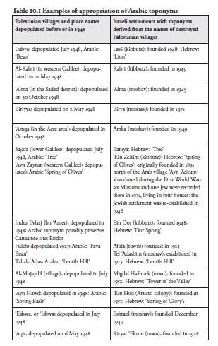
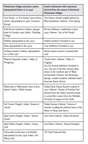
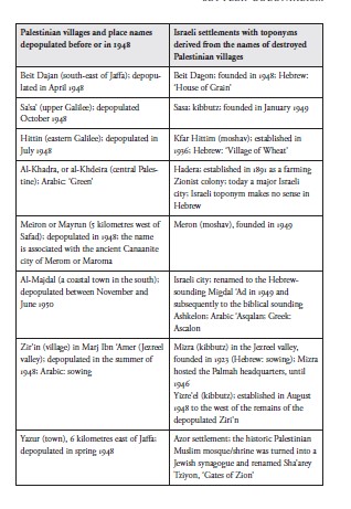
パレスチナ・アラビア語の地名がイスラエルの地名に与えた影響は、アラビア語地名からの借用語、アラビア語地名の翻訳、そして改名の形態的パターンに明確に見て取れる。表10.1は、1948年以前またはその時点で住民が退去させられ破壊されたパレスチナの村々のアラビア語地名に基づき、そこから派生し、あるいはそれをモデルとして作られた、ヘブライ語風の新しい地名を示している。
The influence of Palestinian Arabic toponyms on the Israeli toponyms are clear in loan Arabic place names, translations of Arabic place names and morphological patterns of renaming. Table 10.1 shows new Hebrew-sounding toponyms based on, derived from or modelled on the Arabic toponyms of Palestinian villages depopulated and destroyed before or in 1948.
ナクバから56年後の2004年3月、イスラエルのジャーナリストであるギデオン・レヴィは次のように書いた。「シオニズムの集合的記憶は、私たちの文化的景観にも物理的景観にも存在している。しかし、パレスチナ人が支払った重い代償、すなわち命、数百の村の破壊、そしてパレスチナ難民が今も置かれている苦境は、公的な認知をほとんど受けていない」(Levy 2004)。
Fifty-six years after the Nakba, in March 2004, Israeli journalist Gideon Levy wrote: ‘The Zionist collective memory exists in both our cultural and physical landscape, yet the heavy price paid by the Palestinians – in lives, in the destruction of hundreds of villages, and in the continuing plight of the Palestinian refugees – receives little public recognition’ (Levy 2004).
レヴィはこう付け加えている。
Levy adds:
このサボテンを見てごらん。石の山を覆っている。この石の山は、かつては家だったり、小屋だったり、羊小屋だったり、学校だったり、石垣だったりした。かつて――56年前、一世代半前まで。そう昔のことではない。サボテンは家々と一区画を隔てていた。今では生け垣が、ここにあった暮らしを示す唯一の記念碑にもなっている。 サボテンのまわりの松林も見てほしい。その下にはかつて村があった。405戸の家屋はすべて1948年のある一日に破壊され、2,350人の住民は四散した。このことは誰もわれわれに語ってこなかった。松は、その直後にユダヤ民族基金(JNF)によって植えられた。子どもの頃、われわれは毎週金曜日にそこへ寄付をしていた。その目的は廃墟を覆い隠すこと、帰還の可能性を覆い隠すこと、そしておそらく、ほんの少しの恥と罪悪感も覆い隠すことだった。(Levy 2004)
Look at this prickly pear plant. It’s covering a mound of stones. This mound of stones was once a house, or a shed, or a sheep pen, or a school, or a stone fence. Once – until 56 years ago, a generation and a half ago – not that long ago. The cactus separated the houses and one lot from another, a living fence that is now also the only monument to the life that once was here. Take a look at the grove of pines around the prickly pear as well. Beneath it there was once a village. All of its 405 houses were destroyed in one day in 1948 and its 2,350 inhabitants scattered all over. No one ever told us about this. The pines were planted right afterward by the Jewish National Fund (JNF), to which we contributed in our childhood, every Friday, in order to cover the ruins, to cover the possibility of return and maybe also a little of the shame and the guilt. (Levy 2004)
パレスチナ人の現地調査員と研究者からなるチームが、パレスチナの歴史家ワリード・ハーリディー氏の指揮のもと1992年に発表した記念碑的な研究は、1949年の休戦ラインの内側に位置していた数百の村落の破壊を詳細に記録している。
A monumental 1992 study by a team of Palestinian field researchers and academics under the direction of Palestinian historian Walid Khalidi details the destruction of hundreds of villages falling inside the 1949
休戦ライン。この研究では、各村の占領と住民の退去の経緯、そして残されているものの描写が示されている。カリディのチームは十四の地点を除くすべての場所を訪れ、包括的な報告書を作成し、写真を撮影した。ワリード・カリディ(1992)が記録した418の無人化された村のうち、293(70パーセント)が完全に破壊され、90(22パーセント)が大部分破壊された。7つは残存し、エイン・カリム(エルサレム西方)もその一つだが、イスラエルの入植者に接収された。アラブの風情ある村や地区の一部は、実際には大部分が保存され、高級化されている。しかしそこにはパレスチナ人がおらず(元住民の一部はイスラエル国内の国内避難民である)、ユダヤ人の「芸術家コロニー」に指定されている(Benvenisti 1986: 25; Masalha 2005, 2012)。注意深い旅行者は、破壊されたパレスチナの村々の痕跡を今でも見ることができるが、大半に残っているのは石や瓦礫が点在する光景だけである。しかし新国家はまた、都市の住宅地区、交通インフラ、警察署、鉄道、学校、図書館、教会、モスクといった不動産に加え、書籍、公文書や写真のコレクション、さらには銀製品、家具、絵画、絨毯を含む個人の所持品も自らのものとして接収した(Khalidi, W. 1992)。